Behind the Scenes:Turtle Trapping and Connectivity Mapping for Endangered Blanding’s Turtle Conservation in Southern New Hampshire
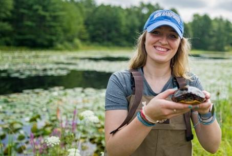
Figure 1: The author., Maeve Kelley. Photo credit: Jeremy Gasowski.
I have always loved driving through the streets of my hometown—Portland, Maine—breathing in the salty air as it drifts into the open car windows. Driving along backroads and listening to my favorite songs is one of my go-to sources of relaxation. As I drove along a winding New Hampshire road for my first day of field research in early June, mesmerized by the dense forests on either side of me, I was once again transported to that familiar meditative state. As I drove up to the pond, I was excited to pull on my waders and get into the water for the first time.
We caught several painted turtles that day. Painted turtles are beautiful and full of personality, and I immediately fell in love. Smiling, I left the pond and shuffled down the secluded dirt road toward my parked car. I was looking down at my big wader boots, and then I stopped in my tracks. There it was—the first dead turtle I had ever seen, right in the middle of the road. It had been hit by a car and was smaller than the palm of my hand. That moment jolted me from my blissful mood and reminded me why we were out there in the first place: to protect these turtles, whose habitat is continuously disturbed by us humans.
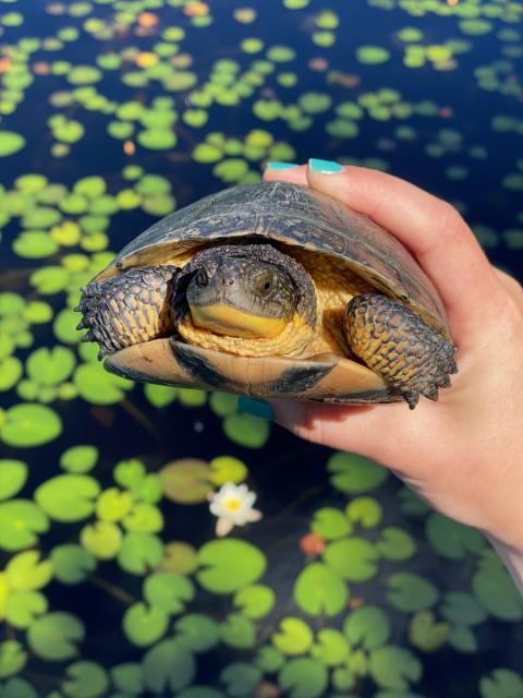
Figure 2: A female Blanding’s turtle (Emydoidea blandingii).
Most of us likely don’t think about roads as much more than a way to get where we need to go. We rely on them for work, education, and recreation, but how often do we stop and think about the other roles that roads play in our environment? As a student of wildlife and conservation biology and animal behavior at the University of New Hampshire (UNH), I consider the impacts of roads on wildlife daily, as they pose multiple threats. Roads are pervasive, growing in density across the landscape. They provide great risk of vehicle collisions, which increases wildlife mortality and creates barriers to movement for many species.
I am curious and passionate about understanding the relationships between wild animals and their environment, and I am especially interested in how we humans alter those relationships. Urban and agricultural development results in habitat disturbances that present a range of obstacles for wildlife. I knew I wanted hands-on experience studying the impacts of human activities on wildlife, and during my junior year my adviser Dr. Jennifer Purrenhage encouraged me to pursue a Summer Undergraduate Research Fellowship (SURF). Dr. Purrenhage (Jen), Dr. Rebecca Rowe, and master’s student Ben Phillips are engaged in ongoing research aimed at assessing changes in the population and community dynamics of freshwater turtles in the increasingly human-occupied landscape of southern New Hampshire. Jen, Becca, and Ben became my research mentors on a complementary study of wetland connectivity, or the degree to which the landscape impedes or facilitates movement, for the endangered Blanding’s turtle (Emydoidea blandingii). (See Figure 2.)
What do we know about freshwater turtles in New Hampshire?
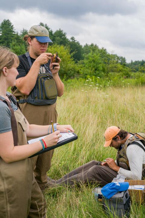
Figure 3: The Turtle Crew collects data on two captured painted turtles (Chrysemys picta). Thomas and the author mark an individual while Ben takes blood from another individual Photo credit: Jeremy Gasowski.
New Hampshire has six native freshwater turtle species: Blanding’s (state endangered), spotted (state threatened), wood (species of special concern), painted, snapping, and musk turtles. The vulnerable status of half of our New Hampshire native turtles is a reflection of the population declines of freshwater turtles worldwide caused by human-caused stressors. Freshwater turtles are among the most vulnerable species, in part because they reproduce relatively late in life, their young have low survival rates, and they depend on multiple habitat types—terrestrial and freshwater—to survive and reproduce.
Habitat destruction and fragmentation by roads can further threaten turtle populations largely through decreased adult survival. More so than other freshwater turtles in New Hampshire, Blanding’s turtles undergo long-distance movements (migrations) each year that force them to travel across roads and other disturbed areas, greatly increasing their risk of vehicle collisions. This increase in mortality can be especially problematic because female turtles are more vulnerable due to their prolonged time on land as they travel to nesting sites to lay their eggs. Higher female mortality leads to a male-skewed sex ratio, and if there are fewer females than males in a population, the potential for breeding and genetic variation decreases. The health of Blanding’s turtle populations largely depends on reducing mortality during overland movements by maintaining or improving connectivity between ponds.
My research aimed to build on the ongoing freshwater turtle study by assessing the degree of connectivity between known Blanding’s turtle ponds in southern New Hampshire and identifying landscape features between ponds that are critical to restore or protect. In a typical week, I spent several days in the field trapping turtles throughout Rockingham and Strafford Counties with the other members of “The Turtle Crew”: Ben Phillips and Thomas Robinson (Wildlife and Conservation Biology alum, UNH 2021). (See Figure 3.) The rest of my time was spent in the computer lab, often with my mentors, using ArcGIS to map important corridors between wetlands and identify potential barriers for turtle movement across the landscape.
How do we know where the turtles are?
First, we needed to figure out which ponds the turtles are using. Generally, Blanding’s turtles inhabit ponds that are adjacent to terrestrial uplands, have stagnant or slow-moving water, and have abundant aquatic vegetation (Compton 2007). The ponds surveyed in this study were selected based on reported sightings of Blanding’s turtles in the region, and ponds determined to be suitable based on their characteristics and location on the landscape.
Each day in the field, we would arrive at a pond, throw on our waders, and march into the water to set or check traps. Walking in waders on a muddy pond floor is not easy, but I managed to fall and flood my waders only a few times throughout the summer. Each week we trapped at six ponds. We used two kinds of funnel traps—larger hoop traps and smaller minnow traps—to target multiple species of turtles. (See Figure 4.) Minnow traps often caught painted, Blanding’s, musk, spotted, and small snapping turtles. The hoop traps would catch large snapping turtles and painted turtles of all sizes.
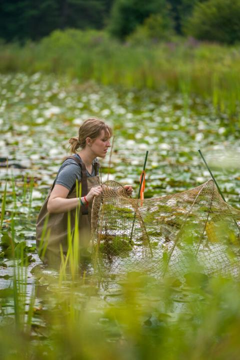
Figure 4: The author sets a large hoop trap in the pond after checking it for turtles. Photo credit: Jeremy Gasowski.
Each turtle was identified to species and sex. We wanted to determine how many turtles are in our New Hampshire wetlands (the population size), but we also wanted to know the number of males versus females (the population’s “sex ratio”) and juveniles versus adults in the population (the population’s “age structure”). Each turtle was logged as either a “recapture” (an individual that had been previously captured and marked) or a “new capture” (an individual that had not yet been captured). We were excited to discover that some of the recaptures had first been marked twenty years earlier during the initial surveys (Marchand and Litvaitis 2004). Together, the data from recaptures and new captures can inform us how populations are growing and about changes in the sex ratio and age structure of the populations.
The identifying features on a recaptured turtle are markings a researcher made on some of the scutes of the turtle’s carapace. The carapace is the top shell, and the scutes are the scales that make up the carapace. To mark a turtle, the scutes along the edges of the carapace are notched using a triangular file in a unique pattern per individual. We also record body measurements for each turtle, including the carapace and plastron (bottom shell) length and width, the pre-cloacal length (distance between the cloaca—opening for the gastrointestinal, urinary, and reproductive systems—and the base of the plastron), and the foreclaw length (middle claw on the right hand).
On a typical day, we would catch one to five snapping turtles and one to ten painted turtles. When we trapped at ponds with Blanding’s turtles, we typically caught two individuals. Snapping turtles that were fifty pounds and fifteen inches long were always a treat to measure or watch Ben measure, as he was much more skilled in the art of turtle taming. The sizes of snapping turtles we caught varied widely from small individuals the size of my hand to large individuals too heavy for me to pick up. (See Figure 5.) Snapping and painted turtle ages ranged from juvenile to adult, but Blanding’s turtles were often adults. Before releasing the turtles back into the pond, we would conclude with a photograph of each individual.
How do mornings spent knee-deep in muck lead to mapping corridors?
My time in the computer lab was different from my time in the field primarily because there were significantly fewer mosquitoes, leeches, and underwater logs to trip on. Our specific objectives were to identify the corridors most likely used by Blanding’s turtles to move between ponds; to identify specific locations on the landscape that are critical for movement between ponds and should be protected; and to identify specific locations that represent current barriers to movement, such as roads. These barriers represent the potential for movement and may become priority areas for restoration to improve connectivity across the increasingly developed landscape of southeastern New Hampshire.
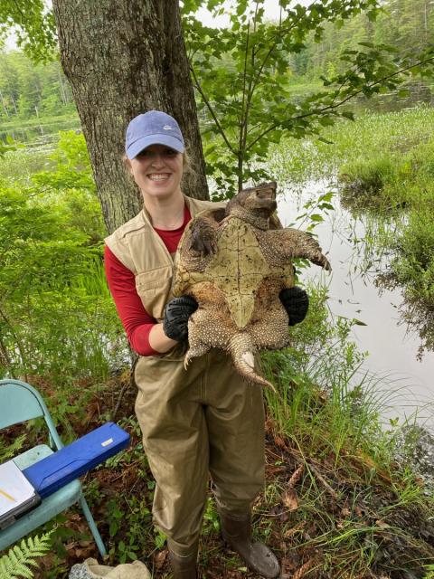
Figure 5: The author holds an adult male snapping turtle (Chelydra serpentina) in the field. Photo credit: Ben Phillips
When Blanding’s turtles move to and from ponds, some land-cover types facilitate movement better than others. The areas that facilitate movement are considered “low resistance.” For instance, streams represent low-resistance land cover because they are preferred habitat for turtles, and they are easier and less dangerous to move through. Farmland, on the other hand, represents moderately resistant land cover, and roads represent high-resistance land cover.
We began by using ArcGIS (a geographic information system) to map the resistance of the landscape within our study area in southern New Hampshire. We assigned resistance values to each land-cover type (e.g., streams and roads), specifically for Blanding’s turtles, using expert opinion data (Steckler and Brickner-Wood 2019). As more of the landscape becomes fragmented by roads and other features linked to high-impact human activities, it is critical that we understand what this means for animals moving across the landscape. Mapping resistance to movement allows us to identify areas across the landscape that inhibit movement, as well as areas that act as connectors and should be protected to facilitate movement.
Once we mapped the resistance values within the study area, we incorporated our field data by mapping the coordinates of each known Blanding’s turtle pond, again by using ArcGIS, a software program commonly used by landscape ecologists. We created a map using the pond locations and land-cover resistance data to understand how difficult it may be for turtles to move between ponds.
Using Linkage Mapper software within our GIS analysis, we mapped all potential corridors between ponds. For each pair of study ponds, we identified the single corridor that requires the least amount of energy for movement between the ponds. This is called the “least cost path,” and it is presumably the primary corridor for movement. However, not every turtle will follow this “primary corridor,” and it is also important to identify the locations on the landscape that are critical for movement between any two ponds (“pinch-points”), regardless of the exact path taken by an individual turtle. These “pinch-points” act as connectors for multiple corridors and thus are priorities for protection to ensure that turtles can continue moving across the landscape.
How can a few maps protect Blanding’s turtles in New Hampshire?
A clear picture of the primary corridors between ponds, and the areas of conservation priority along those corridors, is not only important to maintain connectivity of current turtle populations but can also help us understand how Blanding’s turtles may be expanding their range northwest, toward less-developed areas (Compton 2007).
After completing our analyses using ArcGIS with Linkage Mapper, we can see that the least cost paths provide corridors that we can predict will be used by Blanding’s turtles while they navigate between ponds. We can also see what areas would benefit from restoration for Blanding’s turtles in our six ponds to remain connected.
Humans play a large role in maintaining connectivity for wildlife across the landscape. As I look toward the future of Blanding’s turtles, this analysis could be used to estimate how Blanding’s turtles may use the landscape if they continue to expand their range in New Hampshire. By understanding how connected the landscape is, we can implement conservation efforts to aid success in Blanding’s turtle populations. A simple way to protect Blanding’s turtle populations is to stop for individuals when you see them crossing a road. Vehicle collisions contribute heavily to their mortality and are a factor for all freshwater turtles that use the same landscape we do.
How did freshwater turtles impact my career?
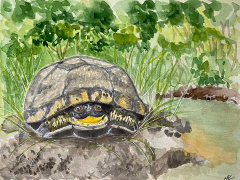
Figure 6. A watercolor painting of a Blanding's turtle by the author.
Throughout this experience I grew as a student, researcher, and conservationist. The fieldwork taught me about the natural history and ecology of freshwater turtles, including what they eat, the types of habitats they use, the types of landscapes that surround their habitat, and the other flora and fauna they coexist with. I gained skills that will be beneficial as I pursue a graduate education—specifically, how to synthesize literature, conduct hands-on fieldwork, map wildlife corridors using GIS to draw conclusions and answer questions, and work as a valuable team member with mentors and co-workers.
This work with an endangered species that I now care so deeply about is something I have never experienced before. My fieldwork with turtles has been the most rewarding and enjoyable work I have done as an undergraduate at UNH. Not only did my project allow me to investigate questions about the current state of wetland connectivity for Blanding’s turtles in New Hampshire, but it also shaped my future aspirations. I firmly believe that I would thrive in a career of fieldwork and hands-on research, similar to the one I experienced last summer, and that leaves me with the certainty and confidence to pursue a graduate education.
I would first like to thank Dr. Jen Purrenhage for guiding me to this incredible experience. Jen significantly helped me achieve all of my goals throughout this process and was a crucial part of my success. She has been not only a supportive adviser, but a supportive mentor. Next, I want to thank Dr. Rebecca Rowe for co-mentoring me throughout this experience and dedicating her time and effort to helping me through every step of this research project with nothing but encouragement. I want to thank Ben Phillips for teaching me all things turtles and making each day in the field meaningful and exciting. Thank you to Thomas Robinson for being the best field tech partner. Lastly, I want to express my sincerest thanks to the Hamel Center for Undergraduate Research for awarding me a Summer Undergraduate Research Fellowship (SURF) USA, and to Mr. Dana Hamel, the Class of 1959 Fund for Excellence, and the UNH Parents Association Undergraduate Research Fund for funding my research and making this opportunity possible.
References
Compton, BW. 2007. Status assessment for the Blanding’s turtle (Emydoidea blandingii) in the Northeast. University of Massachusetts Amherst.
Marchand, M, Litvaitis, J. 2004. Effects of habitat features and landscape composition on the population structure of a common aquatic turtle in a region undergoing rapid development. Conservation Biology 18:758–767.
Steckler, P, Brickner-Wood, D. 2019. Connect the Coast final report. The Nature Conservancy and the Great Bay Resource Protection Partnership. Concord, NH.
Author and Mentor Bios
Maeve Kelley, from South Portland, Maine will graduate in May 2022 with a bachelor of science degree in wildlife and conservation biology and a minor in animal behavior. She is the vice president of Xi Sigma Pi: Natural Resources and the Environment (NREN) Honors Society. In the Summer of 2021, Maeve conducted her research project with a Summer Undergraduate Research Fellowship (SURF) and earned course credit for it that fall. Thanks to this opportunity and her advisor Dr. Jennifer Purrenhage, she was able to gain experience in field work and independent research. Maeve learned a great deal about Blanding’s turtles including their landscape, their behavior, outside threats to their population, and more. She also learned about GIS (Geographic Informational System) and the challenges that came with operating the difficult software. She admitted that running a connectivity analysis was hard, yet she enjoyed problem solving. Of everything, Maeve says the field work was a highlight of her undergraduate career. She shared her research project with Inquiry to inform the public about the importance of her research subject while highlighting the work she did during her final year at UNH. Maeve’s career goal is to work in the field, directly interacting with wildlife for as long as possible. She hopes eventually to earn her master’s degree in wildlife and conservation.
Jennifer Purrenhage is a senior lecturer and program coordinator of wildlife and conservation biology in the Department of Natural Resources and the Environment. She began working at UNH in 2009 as a postdoctoral research associate and joined the faculty in 2013. She specializes in wildlife ecology with a teaching focus on wildlife field methods, conservation biology, and communicating science. Her research focus is on amphibian and reptile conservation. Dr. Purrenhage has previously mentored several undergraduate researchers including Ben Phillips, who is now a graduate student working on turtle research with Drs. Purrenhage and Rowe. Maeve Kelley, her mentee for this turtle study, is the first Inquiry author Dr. Purrenhage has mentored. She is delighted to have been part of this project with Maeve, her co-mentor, Dr. Rebecca Rowe, the other members of the turtle research team, and the turtles. Despite some setbacks and limitations of the pandemic, Dr. Purrenhage said that the time everyone spent together was worth it. She feels that writing for Inquiry’s broader audience is an essential stepping stone to help people in her field become better communicators with non-scientists as well as with each other.
Rebecca Rowe is an associate professor in the Department of Natural Resources and the Environment at UNH. She specializes in landscape and community ecology of vertebrates. Dr. Rowe began working at the university in 2011. She was invited to join Maeve’s project as a co-mentor with Jennifer Purrenhage due to her experience conducting connectivity analyses. “Maeve proved to be an excellent team partner,” she says, “and did a spectacular job of navigating the unexpected challenges which are bound to surface during independent research.” Dr. Rowe finds it rewarding to work with a student as they go through the research process. In 2019 Dr. Rowe mentored two undergraduate researchers who were also Inquiry authors: Corina Danielson and Samm Azen. She finds that learning how to communicate science is a critical way to engage the public in supporting science and sustainable solutions.
Copyright 2022, Maeve Kelley