


UNH Receives $1.8 Million Grant to Study Road Resilience and Flooding
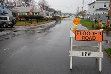
Swelling groundwater caused by increased by sea level rise and excessive rain leaves coastal road closed. Photo credit: Rebecca Zeiber / UNH
DURHAM, N.H.— After a summer of high heat, steady sea level rise and devastating hurricanes like Hurricane Ida, which produced record amounts of rainfall causing destructive and deadly flooding in the Northeast and the Gulf Coast, coastal roads have continued to take a severe beating resulting in endless wear and tear. Because these roadways have become increasingly vulnerable, the National Oceanic and Atmospheric Administration (NOAA) has awarded a $1.8 million grant to researchers at the University of New Hampshire to study how and why coastal hazards like excessive flooding are causing roads to crack and crumble and find ways to protect them.
“We’re trying to better understand the causal links of not only the extreme events but also the gradual changes in sea level rise that can increase the rate of damage to pavement and trigger failures that require major road reconstruction,” said Jo Sias, professor of civil and environmental engineering. “We’re looking at storm surges and wave action but also factors like the amount of time the pavement is under water.”
The focus of the project is to understand the combined hazards of overtopping and subsurface moisture – flooding from above and below the road. UNH researchers – and their partners at the University of South Alabama and the Rockingham Planning Commission - will develop a number of hydrodynamic models that can analyze fluids in motion. They will use new data collected in the field as well as historical information to create high-resolution models to study groundwater and pavement as well as perform an adaptation impact assessment to develop a toolkit to help assess the vulnerability of roadways to flooding hazards. Researchers say that while engineers have investigated these impacts independently, an approach is needed that combines the different effects to better evaluate options when it comes to pavement alternatives. This information will be valuable to state and town officials to assess the impact of sea level rise on the longevity of coastal roadways and help implement practical alternatives for communities to protect the infrastructure.
“It’s important to prioritize and share this information so we can create important decision-making tools, identify institutional barriers and develop policies needed to update state transportation agency coastal resilience practices,” said Sias. “Improving coastal roads to withstand the increasing water hazards is important not only for transportation and the people who live there but also for the overall economy and ecosystems in the area.”
Taking into account factors like climate change and shifting weather patterns, the study will focus on two geographically and geologically diverse coastal regions – the northeast coast of New Hampshire and the southeast coast of Alabama. The research team will work with key end-users to determine adaptation approaches and new management policies and practices for transportation agencies that positively impact surrounding communities.
The grant is part of NOAA’s Effects of Sea Level Rise Program (ESLR) which is based in the National Centers for Coastal Ocean Science (NCCOS). The ESLR provides a suite of science products to inform coastal managers of local coastal vulnerability and solutions to mitigate flood risk.
NCCOS delivers ecosystem science solutions for NOAA’s National Ocean Service and its partners, bringing research, scientific information and tools to help balance the nation’s ecological, social and economic goals.
The University of New Hampshire inspires innovation and transforms lives in our state, nation and world. More than 16,000 students from all 50 states and 71 countries engage with an award-winning faculty in top-ranked programs in business, engineering, law, health and human services, liberal arts and the sciences across more than 200 programs of study. As one of the nation’s highest-performing research universities, UNH partners with NASA, NOAA, NSF and NIH, and receives more than $110 million in competitive external funding every year to further explore and define the frontiers of land, sea and space.
PHOTOS FOR DOWNLOAD
https://www.unh.edu/unhtoday/sites/default/files/media/flooding_hampton_car_briggs.jpeg
Caption: Car attempts to pass through a frequently flooded road in Hampton, N.H. during another bout of flooding caused by a king tide.
Photo Credit: Tim Briggs / UNH
https://www.unh.edu/unhtoday/sites/default/files/media/flooding_aerial_hampton_briggs.jpeg
Caption: Drone shot of section of Hampton, N.H. that experiences excessive flooding which continually submerges coastal roadways.
Photo Credit: Tim Briggs / UNH
https://www.unh.edu/unhtoday/sites/default/files/media/flooding_manchester_st_hampton_briggs.jpeg
Caption: Increased sea level rise leaves roads in a section of Hampton, N.H. underwater during a king tide.
Photo Credit: Tim Briggs / UNH
https://www.unh.edu/unhtoday/sites/default/files/media/flooding_street_sign_briggs.jpeg
Caption: Street sign and mailbox along a road in Hampton, N.H. rise out of flood waters during a king tide.
Photo Credit: Tim Briggs / UNH
Latest News
-
January 12, 2026
-
December 4, 2025
-
November 26, 2025
-
November 6, 2025
-
November 5, 2025