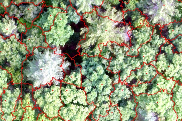
Experiment station researchers have found that the spectral (wavelengths of light) information from natural color imagery more accurately identifies individual tree crowns—the branches and leaves/needles extending from the trunk—than the traditional canopy height model when used in conjunction with unmanned aerial systems.

diameter of the tree trunk at a standard height above the
ground.
In a new study, University of New Hampshire researchers have concluded that when assessing forest imagery collected by unmanned aerial systems, an alternative method of
delineating individual forest tree crowns within those images is more accurate than the most commonly used method, the canopy height model. The research is important to New Hampshire landowners and forest managers as mapping and monitoring forests is a key component of managing natural resources.
Forest data obtained from unmanned aerial systems are gradually becoming an essential part of forest research activities such as ecological and biodiversity modeling and applications such as forest management and field surveys. While aerial system technologies continue to improve and offer more cost-effective ways for collecting data, choosing the most appropriate data and level of detail for making optimal management decisions has become increasingly important. This research evaluated methods for selecting the best data to delineate individual trees.
Jianyu Gu, a postdoctoral research associate with the New Hampshire Agricultural Experiment Station, noted that accurately delineating the tree crowns within the digital imagery—a technique called segmentation—is an ongoing challenge. Developing better methods for segmenting aerial forest images and understanding which methods are best for delineating different tree species can aid in more precise and effective forest management.
Experiment station researchers have found that the spectral (wavelengths of light) information from natural color imagery more accurately identifies individual tree crowns—the branches and leaves/needles extending from the trunk—than the traditional canopy height model when used in conjunction with unmanned aerial systems.
Additionally, the results for a mixed forest—one not dominated by either deciduous or coniferous tree—were not much different than either a conifer or deciduous forest alone. Most previous work in this area was done on conifer forests because the crown shape is easier to detect. However, much of the forested land area in New England and other parts of the United States contains both types of trees.
Improved accuracy in identifying and measuring tree crown size and shape can reveal much about the ecology and competition in the forest, according to experiment station researcher Russ Congalton, professor of natural resources and the environment. Individual tree crowns also are an essential data product for precision forestry. Since New England forests are both mixed and highly dense, these research findings will benefit researchers and foresters. According to the North East State Foresters Association, the annual value of sales of New Hampshire’s forest products industry totals nearly $1.4 billion.

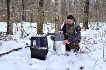
a camera on a pole so that scientists can see the tree canopy
from both above (with the UAS imagery) and below.
“Improvement in geospatial technologies, including the collection of remotely sensed imagery, has substantially increased our ability to generate effective and efficient information about our forests. Recently, the development of unmanned aerial systems has allowed for very cost-effective and high-resolution imagery. This imagery has the potential to provide information at a level of detail beyond what has historically been possible,” Congalton said.
Going forward, researchers plan to further develop additional approaches to delineate individual tree crowns and monitor invasive species. Specifically, they plan to use time-series unmanned aerial systems images between years to develop ways to detect invasive species and model their growth in New Hampshire.
This research is published in the journal Forests in the article "A Comparison of Forest Tree Crown Delineation from Unmanned Aerial Imagery Using Canopy Height Models vs. Spectral Lightness" (DOI: 10.3390/f11060605). Collaborators include Congalton, Gu, and doctoral student Heather Grybas.
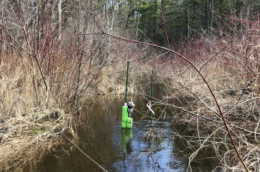
This material is based upon work supported by the NH Agricultural Experiment Station, through joint funding of the National Institute of Food and Agriculture, U.S. Department of Agriculture, under award number 1015520, and the state of New Hampshire. Undergraduate students Vincent Pagano and Hannah Stewart, along with doctoral student Benjamin Fraser assisted with the unmanned aerial systems and reference data collection.
Founded in 1887, the NH Agricultural Experiment Station at the UNH College of Life Sciences and Agriculture is UNH’s original research center and an elemental component of New Hampshire's land-grant university heritage and mission. We steward federal and state funding, including support from the USDA National Institute of Food and Agriculture, to provide unbiased and objective research concerning diverse aspects of sustainable agriculture and foods, aquaculture, forest management, and related wildlife, natural resources and rural community topics. We maintain the Woodman and Kingman agronomy and horticultural research farms, the Macfarlane Research Greenhouses, the Fairchild Dairy Teaching and Research Center, and the Organic Dairy Research Farm. Additional properties also provide forage, forests and woodlands in direct support to research, teaching, and outreach.
The University of New Hampshire is a flagship research university that inspires innovation and transforms lives in our state, nation and world. More than 16,000 students from all 50 states and 71 countries engage with an award-winning faculty in top ranked programs in business, engineering, law, liberal arts and the sciences across more than 200 programs of study. UNH’s research portfolio includes partnerships with NASA, NOAA, NSF and NIH, receiving more than $100 million in competitive external funding every year to further explore and define the frontiers of land, sea and space.
-
Written By:
Lori Tyler Gula, Ph.D., '19 | NH Agricultural Experiment Station | lori.gula@unh.edu | 603-862-1452