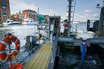
A team of engineers and students from UNH deployed the first autonomous (robotic) surface vessel from a NOAA ship far above the Arctic Circle. Photo Courtesy of Christina Belton, NOAA
A team of engineers and students from UNH’s Center for Coastal and Ocean Mapping (CCOM) recently returned from a voyage that deployed the first autonomous (robotic) surface vessel — the Bathymetric Explorer and Navigator (BEN) — from a NOAA ship far above the Arctic Circle. Deployed from the NOAA hydrographic ship Fairweather, the vessel mapped the seafloor in an effort to improve nautical charts in areas where there is scarce data and increased vessel traffic.
The robotic boat increased the survey coverage of the ship’s efforts by as much as 25 percent during day operations alone and, if integrated into the ship’s routine production survey operations, could be operated by existing shipboard personnel.
The Fairweather spends each summer surveying the seafloor in West Coast and Alaskan waters to improve the nation’s nautical charts. In the Arctic, many of these charts are built from scant sounding data, often from measurements that are hundreds of years old, because there is no additional data. As summer shipping increases in Arctic waters, a national effort is underway to improve the charts to ensure safety, but short summers, limited good weather, remote locations and the vast amount of seafloor to survey make for a daunting task.
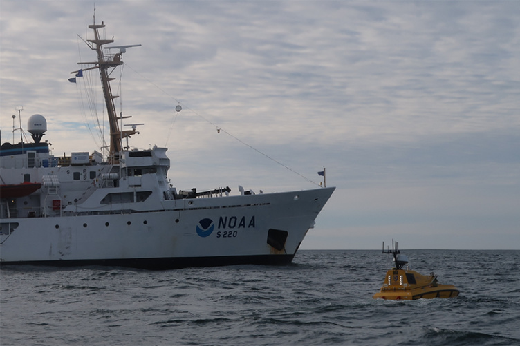
BEN is a robotic vessel designed to aid the ship’s crew in the colossal task of seafloor survey. It was co-designed by UNH engineers and its manufacturer, ASV Global of Houston, Texas. It is 4 meters long, has a top speed of 5.5 knots and a 16-hour endurance. Autonomy software operated aboard the vessel is a combination of open-source robotic operating systems and software developed by engineers Roland Arsenault and Val Schmidt at the CCOM to tailor BEN’s behaviors for hydrographic seafloor survey. BEN is outfitted with state-of-the-art sonar and navigation systems to meet the seafloor survey requirements for nautical charting and safety of navigation. The navigation system provides exact positioning and attitude while BEN plows the ocean’s surface, while the sonar paints a swath of measurements below and to the sides of the vessel.
In this proof-of-concept expedition, BEN operated daily along with the ship’s manned survey launches. The two-person team of BEN operators, which included UNH engineer Andy McLeod and graduate student Lynette Davis along with NOAA hydrographers from the ship’s crew, stayed aboard the Fairweather.
The CCOM is largely funded through grants provided by NOAA’s Office of Coast Survey. The center’s focus is the development of state-of-the-art technologies for ocean mapping and the education of the nation’s hydrographers for nautical charting, oceanographic research and commercial purposes.