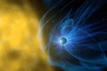
Call it the meteorological equivalent of going from black and white television to ultra-high-definition color. In November, state-of-the-art space weather instrumentation developed by UNH’s Institute for the Study of Earth, Oceans, and Space blasted into space, where scientists will use it to monitor the level of energetic ions that populate the near-Earth space environment and cause potential radiation damage to communications and GPS satellites, commercial airlines and even astronauts with significantly greater accuracy than was previously possible.
Designed, built and calibrated at UNH, the Energetic Heavy Ion Sensor (EHIS) is part of a suite of four space weather instruments on the new National Oceanic and Atmospheric Administration (NOAA) Geostationary Operational Environmental Satellite-R, or GOES-R, weather satellite. The UNH instrumentation will help forecast what’s known as space weather, conditions on the sun and in the Earth’s upper atmosphere, by allowing scientists to more accurately monitor the near-Earth space environment. Near-Earth heavy ions are the main cause of radiation damage in space to both electronic and biological systems.

“An increased heavy ion environment near Earth, which signals higher radiation risk, can affect something as basic as airline altitude,” says Clifford Lopate, research associate professor of physics and principal investigator on the project. “Being able to forecast a higher radiation risk for so-called ‘polar’ planes that tend to fly at higher altitudes near the Earth’s poles would allow airlines to warn pilots and reroute planes to lower altitudes to decrease the risk of long-term exposure to radiation for their crews, who fly the same route over and over again.”
The large majority of positively charged particles in space are protons, followed by helium, then the heavier elements. Monitoring these particles has become an integral part of the NOAA space weather program that tracks and forecasts changes in the environmental conditions in space around the Earth. The EHIS is the first UNH-designed instrument to be included in an operational satellite payload.
And it’s not just about the weather out in space. With five-times faster scanning capabilities and image resolution four times greater than previous satellite technology, GOES-R will also enable improvements to NOAA’s tracking and intensity forecasts here on Earth for severe weather conditions including hurricanes, tornadoes, thunderstorms and flooding.
Originally published in UNH Magazine Spring 2017 Issue
-
Written By:
Robbin Ray ’82 | UNH Marketing | robbin.ray@unh.edu | 603-862-4864