


Professor of Natural Resources and the Environment Russell Congalton has spent close to half a century researching and teaching geographic information systems (GIS), remote sensing and geospatial technologies. During that time, he’s witnessed significant change – which is really just the nature of his work: identifying changing habitats and environments from imagery provided by satellites, unmanned aerial systems (drones), and similar technologies.
Terminology
-
GIS: A system of computer hardware, software, and people used to store, display, manipulate, and analyze spatial data, like elevation, land cover, hydrography, transportation lines, property boundaries, etc.
-
Remote sensing: The process of examining the physical characteristics of an area by measuring its reflected and emitted radiation using a satellite or aircraft.
-
Geospatial: Data or information referring to a particular location or geographic component.
-
Landsat: The NASA/U.S. Geological Survey Landsat program is a series of satellites that have continuously photographed Earth's land surface since the program began in 1972.
“Remote sensing is learning something about an object without touching it,” describes Congalton. “And what we’re really talking about is using light – recording electromagnetic energy from sensors on satellites or other platforms – and we use that imagery to determine the vegetation, land cover or change over time.”
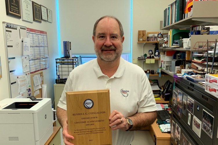
Congalton has been working in this field since the 1980s. He was recently recognized for his work with a Lifetime Achievement Award from AmericaView, a nonprofit closely affiliated with the U.S. Geological Survey that provides Earth observation education and resources through a national consortium of educators and researchers. The achievement is a distinction that only 10 living recipients can have at any one time and awardees are nominated by their AmericaView colleagues.
“The awards process is fairly rigorous,” says Chris McGinty, executive director of AmericaView. “The award has morphed over the years and now really focuses on the entire career of the individual, their contributions to remote sensing and Earth observation, and their support of the AmericaView network. It’s a celebration and recognition of a lifetime of work and dedication to the field.”
And Congalton’s achievements in the industry and with AmericaView are numerous. He founded the New Hampshire consortium, NHView, in 2007, joining together collaborators from throughout the Granite State, including GIS professionals from universities, government agencies, nonprofits, and planning commissions. He’s served as director and chair of the AmericaView Board and helped shape the policies and processes for growing AmericaView from fewer than 20 stateviews (state-based chapters) to 41 stateviews today. He was awarded an Honorary Member/Lifetime Achievement award from the American Society for Photogrammetry and Remote Sensing in 2017.
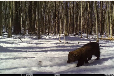
Congalton has taught and studied remote sensing and geographic information systems at UNH since 1991, where his research focuses on using remote sensing, GIS, and other spatial data analysis techniques to solve natural resource issues. At UNH, his projects have included mapping deer, loon, moose, and bear habitats; characterizing New Hampshire forests including evaluating changes over time; identifying and analyzing invasive plant habitats; and managing wildfire and forest fuels.
With the New Hampshire Agricultural Experiment Station at the UNH College of Life Sciences and Agriculture, Congalton is using drones to image New Hampshire lakes, looking for harmful algae blooms to identify which lakes are affected and how they change over time. Establishing that baseline for how our forests and waterways look now, verses in 30-plus years, is especially important when it comes to understanding climate change, invasive species propagation, and the impacts of greenhouse gases.
“In the past, detailed mapping of bodies of water and riparian ecosystems has been problematic using satellite imagery, however the use of UAS now allows us to collect high-resolution imagery and truly assess these habitats,” says Congalton. “We’re now able to see much greater levels of detail which we believe will allow us to better understand these ecosystems in a more efficient and effective manner through this UAS technology.”
"One of the best things that we can do is map and monitor changes over time, so we can see where things are happening. We can see where wetlands are going away, we can see sea-level rise, we can see deforestation happening because of changes in the climate and increases in pests."
“One of the best things that we can do is map and monitor changes over time, so we can see where things are happening,” adds Congalton. “We can see where wetlands are going away, we can see sea-level rise, we can see deforestation happening because of changes in the climate and increases in pests.”
Using remotely sensed imagery, scientists can also develop models for future impacts of natural disasters, like forest fires.
“If we have all the GIS data layers – including land cover, slope and aspect, understory vegetation, humidity, and temperature – we can simulate if a fire started at a certain point, what would burn, how fast would it burn, and what could we do to mitigate that fire” Congalton says. “Then, we could decide to thin the number of trees, or put in fire break, or remove some of the understory all which could help to reduce the severity of a fire if it happened.”
The collaborative nature of working within an organization like AmericaView makes creating these models and understanding their impact on policy changes, response efforts, allocation of resources, and similar initiatives critical.
“It’s really encouraging to be recognized for the contributions that I have worked on throughout my entire career,” adds Congalton. “I especially love AmericaView because we share – everybody shares their ideas; nobody keeps things close to their chest. It’s very collegial.”
Many of Congalton's colleagues in AmericaView share the sentiment and recognize the impact he's had in the geospatial field.
“Russ is not just a highly respected remote sensing researcher and teacher, he is also a great mentor and advocate,” says Joe Knight, Director of the Remote Sensing and Geospatial Analysis Laboratory at the University of Minnesota. “Since I met him, he has consistently given sound advice and generously donated his time to advancing my career. I know he has done the same for many others over the years.”
“Russ continuously strives for excellence, and maintains high standards and aspirations, both for himself and others,” adds John McGee, professor and geospatial extension specialist at the University of Virginia Tech. “He is very gracious with his time, and remains committed to mentoring and educating the workforce of the future. His contributions and impacts, both to the AmericaView organization, and in the field of remote sensing are profound.”
“As a federal executive approving employees’ graduate education requests in the 1990’s, I began reviewing Dr. Congalton’s teaching credentials 30 years ago, impressed by someone as passionate about positional accuracy, derived from remote sensing, as I,” says Roberta Lenczowski, board secretary for AmericaView. “Through his publications and, later, through our professional society conversations and joint participation on technical advisory groups, I recognized his even more influential impact, establishing the foundational principles for assessing thematic or classification accuracy estimates.”
“Through his work, Russ has inspired a generation of geospatial scientists and practitioners – he literally wrote the book on the foundational topic of how we assess the accuracy of what we map, establishing standards that are used throughout the world,” adds Jarlath O'Neil-Dunne '96, director of the Spatial Analysis Lab at the University of Vermont. “A hallmark of Russ’ career is that he has always given back to the larger geospatial community, serving as a journal editor, assuming leadership roles in professional organizations, producing freely available educational content, and answering questions from the thousands of us that use his methods.”
"Russ Congalton’s accuracy assessment research and development of standardized thematic accuracy assessment protocols laid the foundation for the adoption and eventual reliance on remote sensing technologies," says Kass Green, president of Kass Green & Associates. "Only when map accuracy could be reliably and consistently measured and reported, could map users learn to trust and use maps created from remotely sensed data. He also patiently taught me everything I know about remote sensing and GIS, a gift for which I will always be thankful."
Partial support for Russ Congalton’s research at UNH has been provided through joint funding of the National Institute of Food and Agriculture, U.S. Department of Agriculture (currently under award number 1019522) and the state of New Hampshire.
![]()
You can learn more about AmericaView and NHView online, and about Russell Congalton and his work online.
-
Written By:
Nicholas Gosling '06 | COLSA/NH Agricultural Experiment Station | nicholas.gosling@unh.edu