At a time when the novel coronavirus is highlighting the importance of preparing for emergencies and planning for future conditions, Seacoast communities have a new resource to proactively plan for and mitigate the anticipated impacts of climate change.
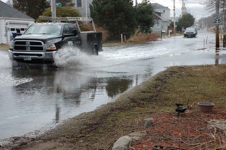
A new document published by UNH provides guidance for N.H. decision-makers who are helping communities prepare for the increased flood risks from sea level rise, storm surge and extreme precipitation expected to impact the state. The document, “Guidance for Using Scientific Projections,” represents part II of the 2019-2020 New Hampshire Coastal Flood Risk Summary. Funded and coordinated by the New Hampshire Department of Environmental Services (NHDES) and written by the New Hampshire Science and Technical advisory panel, the part II guidance document breaks down the science presented in part I of the summary into actions that New Hampshire communities can take to better prepare for future flood events.
“UNH is incredibly proud to be part of this collaborative effort that translates complex climate science into actionable steps for people to follow,” says Cameron Wake, UNH research professor of climatology and glaciology and lead author of Part I of the Summary, which was published in August 2019. “As we have seen in the past few weeks as the coronavirus pandemic has unfolded, the steps we take ahead of time to prepare for future risks are critical to our future well-being.”
The guidance document presents a framework based on tolerance for flood risk that is intended to help decision makers:
- Plan for relative sea level rise (RSLR) estimates that range from 1.3-2.3 feet by 2050, 2.9-6.2 feet by 2100, and 4.6-11.7 feet by 2150;
- Adjust current coastal storm surge depths and extents and augment existing floodplain management and protection standards to account for RSLR;
- Assess risks associated from increasing groundwater levels which are projected to rise as a percentage of RSLR up to three miles inland from the coast;
- Account for projected increases in extreme precipitation by multiplying present-day extreme precipitation rainfall estimates by at least 15%; and
- Identify and evaluate adaptation options to minimize coastal flood risks.
“We have been studying this issue for a long time and it’s very clear we now must start taking definitive actions,” says Thomas O’Donovan, director of the NHDES Water Division. “The guidance, solidly grounded, enables New Hampshire to begin incorporating best available coastal flood risk information in all decisions in order to minimize future damages and protect the natural resources that make this state a great place to live, work, and play. This guidance is a critical step toward helping coastal New Hampshire prepare for what is coming, and NHDES looks forward to working with its many partners to implement it in order to mitigate future flood risks.”
-
Compiled By:
Rebecca Irelan | Institute for the Study of Earth, Oceans, and Space | rebecca.irelan@unh.edu | 603-862-0990