Click below to get more information about UNH graduate programs
Request Information Form
Request Information Form
Earth Sciences
The Master's in Earth Sciences (Ocean Mapping) at UNH offers specialized training in ocean mapping and marine exploration. Here you'll be able to conduct research aboard the R/V Gulf Surveyor while working with advanced technologies at the Center for Coastal and Ocean Mapping.
Through hands-on experience with seabed mapping and habitat analysis, you'll develop the expertise needed for careers in hydrographic surveying, marine research, or ocean resource management.
*Number of courses and course credit hours may vary, please reach out to your academic advisor for exact requirements.
Key Links
Contact Cards
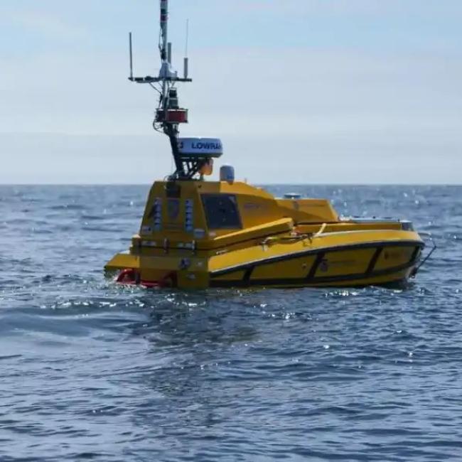
More than 85 percent of the ocean floor is still unexplored. Ocean mappers are modern-day explorers, mastering not only the elements of mapping the seabed, but also becoming adept at such topics as the geologic characterization of the seabed; mapping of living ocean resources and habitats; and development of the tools, sensors and techniques used to map the oceans.
As a student in the ocean mapping program at UNH, you’ll gain experimental, numerical and analytical skills through rigorous classes and research projects. You’ll have access to exceptional equipment and facilities, including the Center for Coastal and Ocean Mapping/Joint Hydrographic Center (CCOM/JHC), one of four data centers for the Seabed 2030 project, which aims to create the definitive map of the world ocean floor; the Jere A. Chase Ocean Engineering Laboratory; and the R/V Gulf Surveyor, a 48-foot ship purpose-designed for ocean mapping activities. Our extensive experimental and computational facilities include a variety of test tanks, autonomous and robotic vehicle development programs, high-performance computing clusters and data stores, and a data visualization laboratory. Most students accepted into our program are supported as research associates through externally-funded grants.
A degree option in Ocean Mapping is for students with interests in hydrography and hydrographic survey technology who wish to prepare for careers in such areas as federal and institutional marine research, federal and international positions in hydrographic surveying, the environment, private sector offshore mineral resources exploration industries, and marine hardware and software development. The study of ocean mapping is a key niche in the ocean technology field.
Hydrography, in the context of this program, is the measurement and definition of the configuration of the bottoms and adjacent land areas of oceans, lakes, rivers, harbors, and other water areas, and the tides (or water levels) and currents that occur in those bodies of water. It includes elements of both physical oceanography, and surveying and mapping.
Ocean mapping is a broader concept that includes not only the elements of hydrography, but also encompasses such topics as the geologic characterization of the seabed and the mapping of living resources and habitats.
An applicant to the M.S. program is expected to have demonstrated competency in the following college courses: one year of calculus, one semester of chemistry, and at least three additional semesters of chemistry, physics, and/or biology. In addition, the applicant is expected to have an undergraduate degree or equivalent in geology, chemistry, physics, mathematics, computer science, engineering, or the biological sciences. Students still working to strengthen a particular component of their foundational coursework may be admitted provided they are prepared to complete courses, in addition to their graduate degree requirements, as needed. The program of study a student wishes to follow and the student's undergraduate major determine the level of preparation necessary. The preparation of each student is determined before the beginning of the first semester in residence in order to plan the course of study. Each entering student is assigned an academic adviser to assist in planning a program of study.
More information is available from the Center for Coastal and Ocean Mapping (CCOM), which oversees this degree program.
This sample degree plan serves as a general guide; students collaborate with their academic advisor to develop a personalized degree plan to meet their academic goals and program requirements.
| First Year | ||
|---|---|---|
| Fall | Credits | |
| ESCI 870 | Geodesy for Ocean Mapping | 3 |
| ESCI 872 | Applied Tools for Ocean Mapping | 2 |
| ESCI 874 | Integrated Seabed Mapping Systems | 4 |
| ESCI 997 | Seminar in Earth Sciences | 1 |
| Credits | 10 | |
| Spring | ||
| ESCI 871 | Positioning for Ocean Mapping | 4 |
| ESCI 875 | Advanced Topics in Ocean Mapping | 4 |
| ESCI 998 | Proposal Development | 1 |
| Credits | 9 | |
| Summer | ||
| ESCI 972 | Hydrographic Field Course | 4 |
| Credits | 4 | |
| Second Year | ||
| Fall | ||
| ESCI 858 | Introduction to Physical Oceanography | 3 |
| ESCI 859 | Geological Oceanography | 4 |
| ESCI 899 | Master's Thesis ( or Elective for non-thesis option) | 3-4 |
| Credits | 10-11 | |
| Spring | ||
| Elective | 3-4 | |
| ESCI 899 or ESCI 898 | Master's Thesis or Directed Research | 2 or3 |
| Credits | 5-7 | |
| Total Credits | 38-41 | |
Students in the thesis option must satisfactorily complete at least 30 graduate credits, which include the credits accumulated in the core curriculum. Students in this option must complete a master's thesis (6 credits) and give an oral presentation of the results.
Students in the non-thesis option must satisfactorily complete at least 34 graduate credits, which includes the core curriculum, a 2-credit directed research project (ESCI 898 Directed Research), and a written and oral presentation of that research.
The core curriculum for the option in ocean mapping normally includes:
| Code | Title | Credits |
|---|---|---|
| Required Courses | ||
| ESCI 997 | Seminar in Earth Sciences (first year) | 1 |
| ESCI 998 | Proposal Development (first year) | 1 |
| Additional Courses | ||
| ESCI 858 | Introduction to Physical Oceanography | 3 or 2 |
| or ESCI 868 | Applied Physical Oceanography for Hydrographic Surveyors | |
| ESCI 859 | Geological Oceanography | 4 or 2 |
| or ESCI 869 | Marine Geology and Geophysics for Hydrographic Surveyors | |
| ESCI 870 | Geodesy for Ocean Mapping | 3 |
| ESCI 871 | Positioning for Ocean Mapping | 4 |
| ESCI 872 | Applied Tools for Ocean Mapping | 2 |
| ESCI 874 | Integrated Seabed Mapping Systems | 4 |
| ESCI 875 | Advanced Topics in Ocean Mapping | 4 |
| ESCI 972 | Hydrographic Field Course | 4 |
| Master's Thesis or Directed Research | ||
| Select from the following: | ||
| ESCI 899 | Master's Thesis | 6 |
| ESCI 898 | Directed Research | 2 |
Students may fulfill the Category A (professional) International Federation of Surveyors/International Hydrographic Organization/International Cartographic Association (FIG/IHO) Standards of Competence for Hydrographic Surveyors by completing some additional specialized requirements.
Program Learning Outcomes
Students graduating with a M.S. in Earth Sciences: Ocean Mapping should achieve the following learning outcomes:Applications must be completed by the following deadlines in order to be reviewed for admission:
Application fee: $65
Campus: Durham
New England Regional: No
Accelerated Masters: Yes (for more details see the accelerated masters information page)
Students claiming in-state residency must also submit a Proof of Residence Form. This form is not required to complete your application, but you will need to submit it after you are offered admission, or you will not be able to register for classes.
If you attended UNH or Granite State College (GSC) after September 1, 1991, and have indicated so on your online application, we will retrieve your transcript internally; this includes UNH-Durham, UNH-Manchester, UNH Non-Degree work and GSC.
If you did not attend UNH, or attended prior to September 1, 1991, then you must upload a copy (PDF) of your transcript in the application form. International transcripts must be translated into English.
If admitted, you must then request an official transcript be sent directly to our office from the Registrar's Office of each college/university attended. We accept transcripts both electronically and in hard copy:
Transcripts from all previous post-secondary institutions must be submitted and applicants must disclose any previous academic or disciplinary sanctions that resulted in their temporary or permanent separation from a previous post-secondary institution. If it is found that previous academic or disciplinary separations were not disclosed, applicants may face denial and admitted students may face dismissal from their academic program.
Recommendation letters submitted by relatives or friends, as well as letters older than one year, will not be accepted.
Prepare a brief but careful statement regarding:
All applicants are encouraged to contact programs directly to discuss program-specific application questions.
Prospective international students are required to submit TOEFL, IELTS, or equivalent examination scores. English Language Exams may be waived if English is your first language. If you wish to request a waiver, then please visit our Test Scores webpage for more information.
Admissions decisions will be based on:
Many of our students receive funding from Teaching Assistantship (TA) or Research Assistantship (RA) positions. Contact potential advisors to discuss sponsorship.
For fall admission, apply by January 15 if seeking funding, and by April 1 for regular admission. For spring admission, apply by December 1. Admission decisions will be made a few weeks after those dates. Admission decisions do not guarantee funding; if funding is offered, a separate offer letter will be sent.
In person program. Most students are full-time students, although different arrangements may be possible depending on the selected research project. Contact potential advisors to discuss alternative arrangements.
Applicants are highly encouraged to reach out directly to faculty with relevant research interests to identify a relevant research project.