


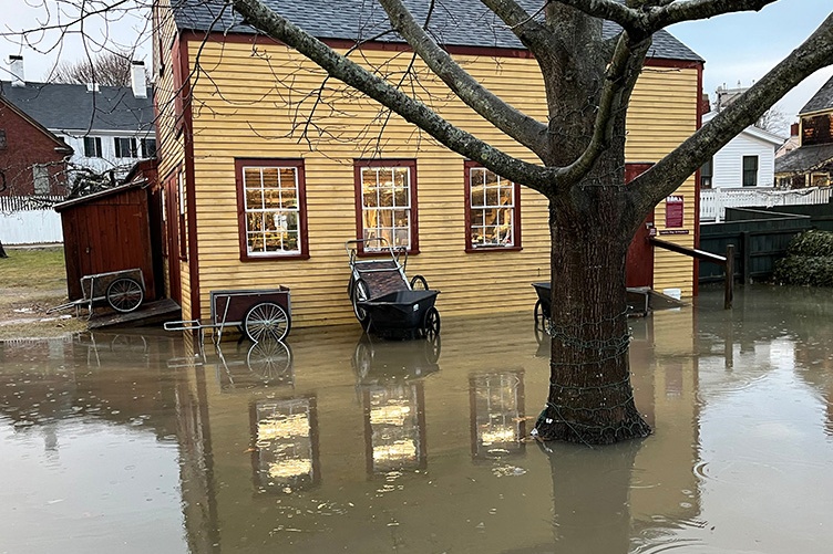
Flooding at the Strawbery Banke Museum property from a January 2024 storm was among the worst seen thus far. (Photo courtesy of Strawbery Banke Museum)
Rising sea levels and more frequent flooding have combined to become an increasingly alarming challenge for the Strawbery Banke Museum in Portsmouth, where basements on this historic property are now routinely threatened by groundwater intrusion during events like King Tides and storm surges.
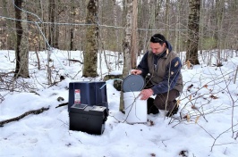
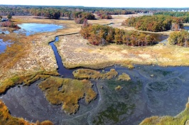
UNH researchers are playing a key role in helping Strawbery Banke formulate a plan to combat those challenges, having placed sensors in several basements and the nearby Piscataqua River that provide critical data to decision-makers at the museum and the city of Portsmouth.
With a couple of clicks of a mouse and taps on a keyboard from his desk in Morse Hall, Michael Routhier, researcher at UNH’s Earth Systems Research Center, can see virtually real-time data on water levels in some of the basements at Strawbery Banke, measuring things like salinity levels and temperature, as well.
Being able to monitor that information essentially on-demand provides a fuller picture of what is happening now and an opportunity to better predict what might need to take place in the future to preserve the iconic structures.

“We’re looking to see how much flooding is occurring in these basements and how that flooding is affecting the overall fabric of the buildings. This can include the actual deterioration of the foundation from the water coming in, as well as things like humidity rotting wood and rusting fasteners,” Routhier says. “Knowing what these measurements are allows the decision-makers to have a better sense of how to mitigate or adapt to what has been happening and what’s coming down the road.”
UNH’s quest to help Strawbery Banke combat these challenges dates back to 2012, Routhier says, when water sensors were initially placed in a few basements and wells were drilled in the green space in front of the museum’s visitor center.
But those sensors weren’t transmitting wireless information, meaning researchers had to go back every couple of weeks to pull the sensors out of the wells and plug them into a laptop to receive and review the data.
Advancements in technology have since made it possible to place sensors with cell phones attached that can push data directly to the cloud, and Routhier and his team have built an interface where it is possible to watch water levels go up and down on a feed that receives data every five minutes.
Those newer sensors were placed in two buildings on the property – the Shapley, Pridham House and the Jones House – in early 2023, and another was added in the nearby Piscataqua River around Thanksgiving 2023.
“We suspected back in 2012 when we put the first sensors in that flooding was related to the tidal patterns in the river, but now that we put in the new sensors, we’re able to see the relationship between the tidal patterns in the river and what is happening in the basements, live,” Routhier says. “And what we’re able to tell is that there is approximately a half-hour delay between when we hit high tide in the river and when the water pressure pushes the water table up into the basement of the closest house.”
“Knowing what these measurements are allows the decision-makers to have a better sense of how to mitigate or adapt to what has been happening and what’s coming down the road.”
Those learnings have been important, as it’s now possible for Rodney Rowland, director of facilities at Strawbery Banke, to see when water is rising in the nearby Piscataqua River, quickly alerting him that they might see basement flooding in the next 30 minutes or so.
What has become readily apparent is that incidents of groundwater inundation are happening more frequently and the flooding is becoming more severe. A recent round of rain in January produced the highest numbers Routhier has seen recorded thus far, and Rowland anecdotally noted he’d never seen flooding as bad at the Strawbery Banke campus.
“It’s good timing that we have these sensors out there now, because they are providing evidence as to what’s happening currently and what could happen in the long run – the inundation numbers are getting bigger and more frequent,” Routhier says. “And the city of Portsmouth is really interested in what’s happening, too, because what’s happening at Strawberry Banke has an impact on the future of the city as well.”
How to manage that impact is the biggest challenge ahead, and a big part of what the data being collected will help inform. The Penhallow House at Strawberry Banke recently had to be raised more than 10 feet off the ground so a new foundation with advanced drainage could be built – a last resort for a property focused on historical preservation – and it’s possible that similar updates will be needed to other buildings on the property.
There is also talk of building a retention pond in green space on the property to help pull some of the groundwater away from the houses.
As those solutions are considered, Routhier says he’s excited that UNH can be involved in a project with such significant impact that could potentially shape the future of the surrounding city.
“I think it’s great from multiple perspectives,” Routhier says. “From the community engagement perspective because of Strawberry Bank’s link to our coastal cultural heritage, from a science perspective, because of how rising sea levels and increased frequency of storms is not just a local issue but a regional to global issue as well, and from a policy perspective because of how we can use cutting edge technologies to better inform decisions that will help our communities survive and thrive.”
-
Written By:
Keith Testa | UNH Marketing | keith.testa@unh.edu